The city has a significant population of Turkic Crimean Tatars. It also attracted ethnic Turks emigrating from Balkancountries such as Bulgaria, Romania, Bosnia, and the Sandžak region of Serbia, who contributed to the development of the city's metalworking industries. Eskişehir also hosted the inaugural Türkvizyon Song Contest in 2013, which aims to highlight music and artists from various Turkish countries and regions. The city is also home to the Dünya Müzeleri Müzesi or Museum of World Museums.
The Windmill, Şelale Park,
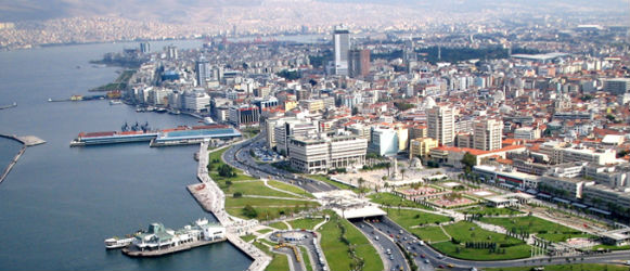
Eskişehir is a city in northwestern Turkey and the capital of the Eskişehir Province. According to the 2011 census, the population of the city is 648,396. The city is located on the banks of the Porsuk River, 792 m above sea level, where it overlooks the fertile Phrygian Valley. In the nearby hills one can find hot springs. The city is 233 km (145 mi) to the west of Ankara, 330 km (205 mi) to the southeast of Istanbul and 78 km (48 mi) to the northeast of Kütahya. Known as a university town, both Eskişehir Osmangazi University and Anadolu University (which has one of the largest student enrollments in the world) are based in Eskişehir. The province covers an area of 2,678 km2(1,034 sq mi).
Reşadiye Camii
According to the Turkish Statistical Institute, as of 2011 the Eskişehir Metropolitan Municipality had a population of 648,396.
The name Eskişehir literally means Old City in Turkish; indeed, the city was founded by the Phrygians in around 1000 BC. Many Phrygian artifacts and sculptures can still be found in the city's archeological museum. There is also a museum of meerschaum stone, whose production remains still notable, used to make high quality meerschaumpipes. In the fourth century AD the city moved about ten km northeast, from Karacahisar to Şehirhöyük.
Fairy Tale Castle
Whenever it was mentioned by ancient geographers, the city was described as one of the most beautiful in Anatolia.
As with many towns in Anatolia, Christianity arrived after Constantine the Great made it the official religion of theRoman Empire. Beginning in the 4th century, records exist of bishops holding office in Eskişehir. The city was known as Dorylaeum in that period. One of these bishops, Eusebius, was heavily involved in shaping the evolving dogma of the church.
Most of modern-day Eskişehir was rebuilt after the Turkish War of Independence (1919-1922), but a number of historic buildings remain, such as the Kurşunlu Cami Mosque. The archaeological site of the ancient Phrygian city of Dorylaeum is close to Eskişehir. The city is noted for its natural hot sulphur springs.
Eskişehir has a continental climate with a warm summer subtype (Dsb) under Köppen climate classification, with cold, snowy winters with an average of −0.1 °C (31.8 °F) and warm, dry summers with average highs reaching 29 °C (84.2 °F). Rainfall occurs mostly during the spring and autumn. Due to Eskişehir's high altitude and its dry summers, nightly temperatures in the summer months are cool. Precipitation levels are low, but precipitation can be observed throughout the year.
What better way to get some exercise during the cold winter months?
The following list of America’s top resorts can be compared based on
their terrain, mountain stats, number of lifts, and proximity
of accommodations and overall value.
Breckenridge Ski Resort is an alpine ski resort in the westernUnited States, in Breckenridge, Colorado. Just west of the Continental Divide in Summit County, it is perennially one of the most visited ski resorts in the western hemisphere. Breckenridge is owned and operated by one of the world's leading ski resort operators, Vail Resorts, Inc., which also operates other ski resorts in Colorado (Vail, Beaver Creek, and Keystone), Utah (Canyons), Michigan (Mt. Brighton), Minnesota (Afton Alps), and California (Heavenly, Kirkwood, and Northstar at Lake Tahoe).
Breckenridge is spread out across the five peaks that make up the southern half of the Tenmile Range. The second oldest peak, the lower part of Peak 9 is a beginner
learning slope, accessed by Quicksilver Super6 and Lift A. On the upper
part of Peak 9 are intermediate blue runs serviced by the Mercury
SuperChair, Beaver Run SuperChair, and Lift C. On the north side of Peak
9, facing towards Peak 8, are the North Chutes, double black-rated
chutes serviced by Lift E. Lift E also functions as an access lift to
transition from Peak 8 to Peaks 9 and 10. Until they were replaced beginning in 2012, Peak 9 directional trail signs could be identified with orange arrows.
The Breckenridge chairlift system has broken new ground over the
years by implementing several new state-of-the-art engineering marvels,
and the system today includes several renowned lifts, such as the sole
double-loading lift in North America and the highest lift in North America.
First High Speed Quad in the World (Quicksilver Quad, 1981, now runs at Owl's Head in Quebec)
First (and only) double loading lift in North America (Quicksilver Six, 1999)
Highest Lift in North America (Imperial Express SuperChair, 2005)
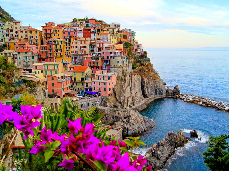
Manarola (Manaea in the local dialect) is a small town, a frazione of the comune (municipality) of Riomaggiore, in the province of La Spezia, Liguria, northern Italy. It is the second smallest of the famous Cinque Terre towns frequented by tourists. Manarola may be the oldest of the towns in the Cinque Terre, with the
cornerstone of the church, San Lorenzo, dating from 1338. The local
dialect is Manarolese, which is marginally different from the dialects
in the nearby area. The name "Manarola" is probably dialectical
evolution of the Latin, "magna rota". In the Manarolese dialect this was changed to "magna roea" which means "large wheel", in reference to the mill wheel in the town.
Manarola's primary industries have traditionally been fishing and wine-making. The local wine, called Sciacchetrà, is especially renowned; references from Roman
writings mention the high quality of the wine produced in the region.
In recent years, Manarola and its neighboring towns have become popular
tourist destinations, particularly in the summer months. Tourist
attractions in the region include a famous walking trail between
Manarola and Riomaggiore (called Via dell'Amore, "Love's Trail")
and hiking trails in the hills and vineyards above the town. Manarola is
one of the five villages. Mostly all of the houses are bright and
colourful. Manarola was celebrated in paintings by Antonio Discovolo (1874-1956).
A new town, founded by the will of King Louis XIV, it was the de facto capital of the kingdom of France for over a century, from 1682 to 1789, before becoming the cradle of the French Revolution. After having lost its status of royal city, it became the préfecture (regional capital) of Seine-et-Oisedépartement in 1790, then of Yvelines in 1968, and a Roman Catholic diocese. Versailles is historically known for numerous treaties such as the Treaty of Paris (1783), which ended the American Revolutionary War and the Treaty of Versailles, after World War I.
Located in the western suburbs of the French capital, 17.1 km (10.6 mi) from the centre of Paris, Versailles is in the 21st century a wealthy suburb of Paris with a service based economy and a major touristic destination as well. In addition, the Congress of France - the name given to the body created when both houses of the French Parliament, the National Assembly and the Senate, meet - gathers in the Château de Versailles to vote on revisions to the Constitution. The name of Versailles appears for the first time in a medieval
document dated 1038. In the feudal system of medieval France, the lords
of Versailles came directly under the king of France, with no
intermediary overlords between them and the king; yet they were not very
important lords. In the end of the 11th century, the village curled
around a medieval castle and the Saint Julien church. Its farming
activity and its location on the road from Paris to Dreux and Normandy brought prosperity to the village, culminating in the end of the 13th century, the so-called "century of Saint Louis", famous for the prosperity of northern France and the building of Gothic cathedrals. The 14th century brought the Black Plague and the Hundred Years' War,
and with it death and destruction. At the end of the Hundred Years' War
in the 15th century, the village started to recover, with a population
of only 100 inhabitants.
In 1561, Martial de Loménie, secretary of state for finances under King Charles IX,
became lord of Versailles. He obtained permission to establish four
annual fairs and a weekly market on Thursdays. The population of
Versailles was 500 inhabitants. Martial de Loménie was murdered during
the St. Bartholomew's Day massacre (24 August 1572). In 1575, Albert de Gondi, a man from Florence who had come to France with Catherine de' Medici, bought the seigneury of Versailles.
Versailles' primary cultural attraction is the Palace, with its ornately
decorated rooms and historic significance. The town also has other
points of cultural notability; in recent times, its position as an
affluent suburb of Paris has meant that it forms a part of the Paris
artistic scene, and musical groups such as Phoenix, Air and Daft Punk have some link to the city, as does the director Michel Gondry.
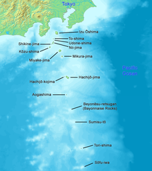
Aogashima is a volcanicJapanese island in the Philippine Sea. The island is administered by Tokyo and located approximately 358 kilometres (222 mi) south of Tokyo and 64 kilometres (40 mi) south of Hachijō-jima. It is the southernmost and most isolated inhabited island of the Izu archipelago.
Aogashima is a complex Quaternary volcanic island 3.5 km in length with a maximum width of 2.5 km, formed by the overlapping remnants of at least four submarine calderas. The island is surrounded by very steep rugged cliffs of layered volcanic deposits. The southern coast also rises to a sharp ridge forming one edge of a caldera named Ikenosawa (池之沢?) with a diameter of 1.5 km. The caldera dominates the island, with one point on its southern ridge, Otonbu (大凸部?) with a height of 423 metres (1,388 ft), as the island’s highest point. The caldera is occupied by a secondary cone named Maruyama (丸山).
Still considered a Class-C active volcano by the Japan Meteorological Agency, the last eruption of Aogashima was during a four-year period from 1781-1785.
The history of human settlement on Aogashima is uncertain. Most of the people in Aogashima are Japanese. The island is mentioned inEdo period records kept at Hachijō-jima, which record volcanic activity in 1652, and from 1670-1680. An earthquake swarm in July 1780 was followed by steam rising from the lakes in the Ikenosawa Caldera. Further earthquakes in May 1781 led to an eruption. In April 1783,lava flows from the Maruyama cone resulted in the evacuation of all 63 households on the island. During a massive eruption in 1785, some 130-140 of the population of 327 islanders perished.
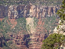
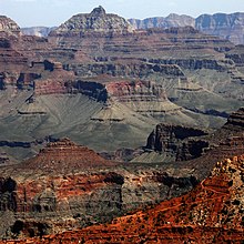
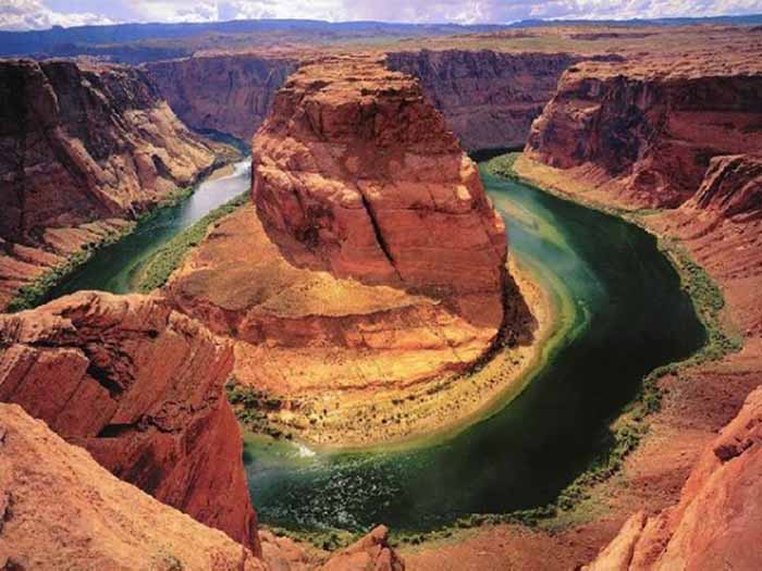
The Grand Canyon is 277 miles (446 km) long, up to 18 miles (29 km) wide and attains a depth of over a mile (6,000 feet or 1,800 meters). Nearly two billion years of Earth's geological history have been exposed as the Colorado River and its tributaries cut their channels through layer after layer of rock while the Colorado Plateau was uplifted. While the specific geologic processes and timing that formed the Grand Canyon are the subject of debate by geologists, recent evidence suggests that the Colorado River established its course through the canyon at least 17 million years ago. Since that time, the Colorado River continued to erode and form the canyon to its present-day configuration.
For thousands of years, the area has been continuously inhabited by Native Americans who built settlements within the canyon and its many caves. The Pueblo people considered the Grand Canyon ("Ongtupqa" in the Hopi language) a holy site, and made pilgrimages to it. The first European known to have viewed the Grand Canyon was García López de Cárdenas from Spain, who arrived in 1540.
The Ancient Pueblo People were a Native American culture centered on the present-day Four Corners area of the United States. The Ancient Puebloans were the first people known to live in the Grand Canyon area. The cultural group has often been referred to in archaeology as the Anasazi, although the term is not preferred by the modern Puebloan peoples. The word "Anasazi" is Navajo for "Ancient Ones" or "Ancient Enemy".
Archaeologists still debate when this distinct culture emerged. The current consensus, based on terminology defined by the Pecos Classification, suggests their emergence around 1200 BCE during the Basketmaker II Era. Beginning with the earliest explorations and excavations, researchers have believed that the Ancient Puebloans are ancestors of the modern Pueblo peoples.
In addition to the Ancestral Puebloans, a number of distinct cultures have inhabited the Grand Canyon area. The Cohonina lived to the west of the Grand Canyon, between 500 and 1200 CE. The Cohonina were ancestors of the Yuman, Havasupai, and Walapaipeoples who inhabit the area today.
The Sinagua were a cultural group occupying an area to the southeast of the Grand Canyon, between the Little Colorado River and theSalt River, between approximately 500 and 1425 CE. The Sinagua may have been ancestors of several Hopi clans.
By the time of the arrival of Europeans in the 16thcentury, newer cultures had evolved. The Hualapai inhabit a 100-mile (160 km) stretch along the pine-clad southern side of the Grand Canyon. The Havasupai have been living in the area near Cataract Canyon since the beginning of the 13thcentury, occupying an area the size of Delaware. The Southern Paiutes live in what is now southern Utah and northern Arizona. The Navajo, or Diné, live in a wide area stretching from the San Francisco Peaks eastwards towards the Four Corners. Archaeological and linguistic evidence suggests the Navajo descended from the Athabaskan people near Great Slave Lake, Canada, who migrated after the 11thcentury.
The Upper Sonoran Life Zone includes most of the inner canyon and South Rim at elevations from 3,500 to 7,000 feet (1,100 to 2,100 m).[50] This zone is generally dominated by blackbrush, sagebrush, and pinyon-juniper woodlands. Elevations of 3,500 to 4,000 feet (1,100 to 1,200 m) are in the Mojave Desert Scrub community of the Upper Sonoran. This community is dominated by the four-winged saltbush and creosote bush; other important plants include Utah agave, narrowleaf mesquite, ratany, catclaw, and various cactispecies.
Approximately 30 bird species breed primarily in the desert uplands and cliffs of the inner canyon. Virtually all bird species present breed in other suitable habitats throughout the Sonoran and Mohave deserts. The abundance of bats, swifts, and riparian birds provides ample food for peregrines, and suitable eyrie sites are plentiful along the steep canyon walls. Also, several critically endangeredCalifornia Condors that were re-introduced to the Colorado Plateau on the Arizona Strip, have made the eastern part of the Park their home.
Above the desert scrub and up to 6,200 feet (1,900 m) is a pinyon pine forest and one seed juniper woodland. Within this woodland one can find big sagebrush, snakeweed,Mormon tea, Utah agave, banana and narrowleaf Yucca, winterfat, Indian ricegrass, dropseed, and needlegrass. There are a variety of snakes and lizards here, but one species of reptile, the mountain short-horned Lizard, is a particularly abundant inhabitant of the piñon-juniper and ponderosa pine forests.
Montane meadows and subalpine grassland communities of the Hudsonian life zone are rare and located only on the North Rim. Both are typified by many grass species. Some of these grasses include blue and black grama, big galleta, Indian ricegrass and three-awns. The wettest areas support sedges and forbs.
Grand Canyon National Park is one of the world's premier natural attractions, attracting about five million visitors per year. Overall, 83% were from the United States: California (12.2%), Arizona (8.9%), Texas (4.8%), Florida (3.4%) and New York (3.2%) represented the top domestic visitors. Seventeen percent of visitors were from outside the United States; the most prominently represented nations were the United Kingdom (3.8%), Canada (3.5%), Japan (2.1%), Germany (1.9%) and The Netherlands (1.2%). The South Rim is open all year round weather permitting. The North Rim is generally open mid-May to mid-October.
 The city has a significant population of Turkic Crimean Tatars. It also attracted ethnic Turks emigrating from Balkancountries such as Bulgaria, Romania, Bosnia, and the Sandžak region of Serbia, who contributed to the development of the city's metalworking industries. Eskişehir also hosted the inaugural Türkvizyon Song Contest in 2013, which aims to highlight music and artists from various Turkish countries and regions. The city is also home to the Dünya Müzeleri Müzesi or Museum of World Museums.