
Legend says that a magician once swam to Iceland in the form of a whale, hoping to bring the isolated North Atlantic island under his spell. But when he reached Iceland’s rocky shores, he abandoned his dream upon discovering that it was already inhabited by spirits who fiercely defended their lush green meadows, frigid ice sheets, and soaring volcanic mountains.
In Iceland: Fire and Ice, NATURE takes an inspiring look at the real spirits — both human and wild — that thrive in a challenging land where fire literally meets ice. Iceland: Fire and Ice offers a stunning portrait of this island of extremes, where some of Europe’s biggest glaciers cozy up to some of the continent’s hottest volcanic springs. And it profiles many of the remarkable animals, such as birds from the lethal gyrfalcon to the comic, clown-billed puffin, that bring vibrant life to an occasionally desolate landscape.

To Iceland’s earliest human settlers, who arrived from Europe sometime in the 9th century, the island’s ruggedly beautiful lava flows, smoking volcanic vents, and roaring waterfalls seemed inconceivably ancient. Some imagined them to be the sculpted remains of some timeless battlefield, where their immortal gods had waged a merciless war. In fact, however, Iceland is a mere child in geologic terms. It was formed by volcanic eruptions just 20 million years ago, as magma poured from the Mid-Atlantic Ridge, a tear in the seabed that marks the boundary between the North American and European continental plates. As the liquid rock oozed out of the tear and cooled, it produced the island we see today: a 300-mile-long, 200-mile-wide oval landmass that sits between Greenland and the European coast in the icy seas near the Arctic Circle.
But Iceland’s construction is far from over. Today, it boasts more than two dozen active volcanoes that regularly erupt and add more lava and ash to the landscape. Indeed, Icelanders experience an eruption twice a decade on average, with the scenic Mount Hekla being one of the island’s most energetic volcanoes in recent years. While eruptions often consist of little more than a spit of smoke and a cough of ash, sometimes they can mean spectacular and dangerous geologic fireworks. In the late 18th century, for instance, Iceland’s Mount Lakagigar produced the world’s largest lava flow — more than 3 cubic miles of molten rock. Thousands of farm animals were gassed to death by the mountain’s poisonous fumes, and the eruption produced so much ash that the sky was dark for weeks. The eruption wreaked havoc on the island’s food supply, causing a famine; more than a third of Iceland’s people died.

Other memorable volcanic disasters aren’t so old. In 1973, the eruption of the Eldfell volcano threatened to entomb the nearby fishing village of Heimaey in magma. Boiling rivers of lava engulfed a third of the town before desperate islanders mounted a bold and creative defense against the mountain. Using hastily installed fire hoses and water pumps, the villagers sprayed the encroaching lava with streams of frigid seawater, forcing it to crystallize. The resulting rock dam diverted the lava rivers away from the town and into the sea. Ironically, by the time the eruption was over, the lava had formed a new spit of land that offered improved protection to the town’s harbor.

Vulcanism is not only one of Iceland’s hallmarks; it is also responsible for the island nation’s best-known contribution to other languages. The word “geyser” comes from a single celebrated spring in southwestern Iceland that every so often flings its waters, heated to boiling by the volcanic magma below, several hundred feet into the air. Today, volcanic fountains all over the world carry the name given to this Icelandic wonder, which has become less active in recent years. But many other hot springs continue to provide Icelanders with an important source of energy — and natural saunas perfect for a winter warm-up.

Volcanic fire isn’t the only elemental force shaping the island. Ice, too, plays a key role. Less than 8,000 years ago, geologists believe the entire island was buried beneath miles of ice. As these massive glaciers melted away, they carved Iceland’s remarkable steep-sided valleys and fjords, long, narrow glacial valleys that have been flooded by the sea. Today, ice continues to carve and smooth the land. About ten percent of the island is covered by glaciers. The largest, called Vatnajokull, is already more than a half-mile deep and covers about 3,000 square miles. It is Europe’s largest glacier. Indeed, all of the continent’s other ice caps would comfortably fit within Vatnajokull.

But the massive ice sheet isn’t Iceland’s only record-breaker. The island also boasts the continent’s largest and most powerful waterfall: the Gullfoss, or “Golden Falls.” Once, government planners had considered the 105-foot cascade a perfect place to build a hydroelectric dam. But folklore says a young woman threatened to throw herself over the falls if plans to destroy the natural monument went forward. Her threat worked, and today the site is protected by a national park. So, on a sunny day, the Gullfoss continues to sparkle with countless rainbows, drawing thousands of onlookers each year to view the spectacle. Like the early settlers before them, they can only marvel at the natural beauty crafted by the unlikely union of fire and ice.

 Linguistically, Minicoy remains linked to the rest of the island group.
 Legend says that a magician once swam to Iceland in the form of a whale, hoping to bring the isolated North Atlantic island under his spell. But when he reached Iceland’s rocky shores, he abandoned his dream upon discovering that it was already inhabited by spirits who fiercely defended their lush green meadows, frigid ice sheets, and soaring volcanic mountains.
 To Iceland’s earliest human settlers, who arrived from Europe sometime in the 9th century, the island’s ruggedly beautiful lava flows, smoking volcanic vents, and roaring waterfalls seemed inconceivably ancient. Some imagined them to be the sculpted remains of some timeless battlefield, where their immortal gods had waged a merciless war. In fact, however, Iceland is a mere child in geologic terms. It was formed by volcanic eruptions just 20 million years ago, as magma poured from the Mid-Atlantic Ridge, a tear in the seabed that marks the boundary between the North American and European continental plates. As the liquid rock oozed out of the tear and cooled, it produced the island we see today: a 300-mile-long, 200-mile-wide oval landmass that sits between Greenland and the European coast in the icy seas near the Arctic Circle.
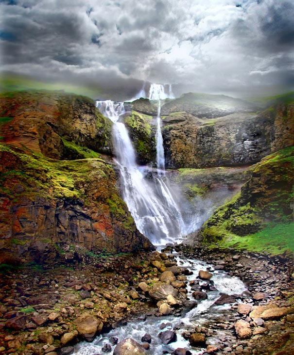 Other memorable volcanic disasters aren’t so old. In 1973, the eruption of the Eldfell volcano threatened to entomb the nearby fishing village of Heimaey in magma. Boiling rivers of lava engulfed a third of the town before desperate islanders mounted a bold and creative defense against the mountain. Using hastily installed fire hoses and water pumps, the villagers sprayed the encroaching lava with streams of frigid seawater, forcing it to crystallize. The resulting rock dam diverted the lava rivers away from the town and into the sea. Ironically, by the time the eruption was over, the lava had formed a new spit of land that offered improved protection to the town’s harbor.
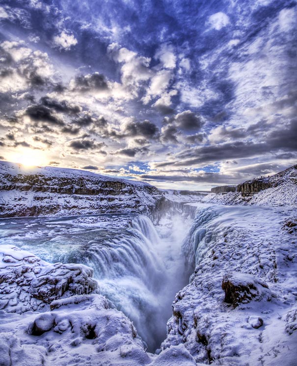 Vulcanism is not only one of Iceland’s hallmarks; it is also responsible for the island nation’s best-known contribution to other languages. The word “geyser” comes from a single celebrated spring in southwestern Iceland that every so often flings its waters, heated to boiling by the volcanic magma below, several hundred feet into the air. Today, volcanic fountains all over the world carry the name given to this Icelandic wonder, which has become less active in recent years. But many other hot springs continue to provide Icelanders with an important source of energy — and natural saunas perfect for a winter warm-up.
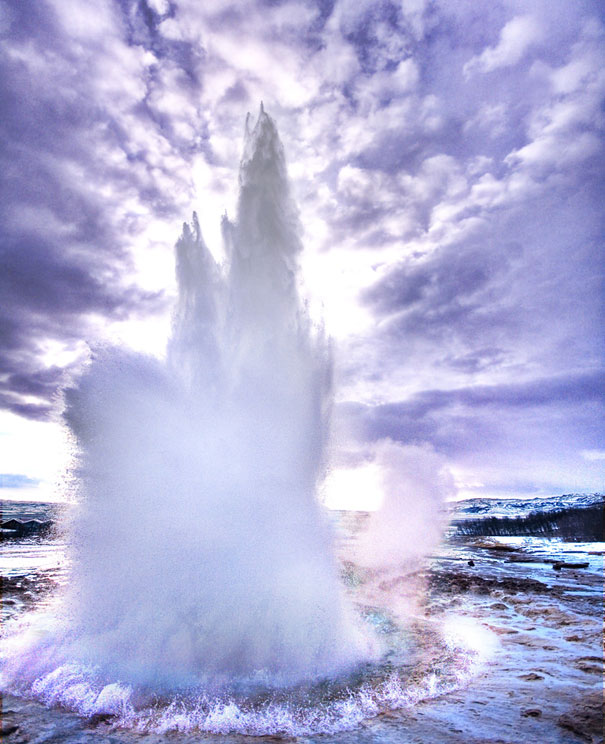 Volcanic fire isn’t the only elemental force shaping the island. Ice, too, plays a key role. Less than 8,000 years ago, geologists believe the entire island was buried beneath miles of ice. As these massive glaciers melted away, they carved Iceland’s remarkable steep-sided valleys and fjords, long, narrow glacial valleys that have been flooded by the sea. Today, ice continues to carve and smooth the land. About ten percent of the island is covered by glaciers. The largest, called Vatnajokull, is already more than a half-mile deep and covers about 3,000 square miles. It is Europe’s largest glacier. Indeed, all of the continent’s other ice caps would comfortably fit within Vatnajokull.

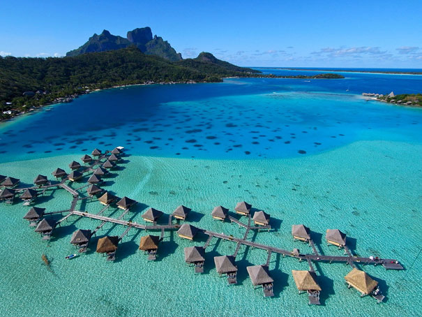
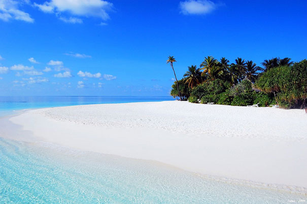
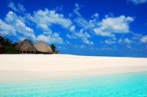
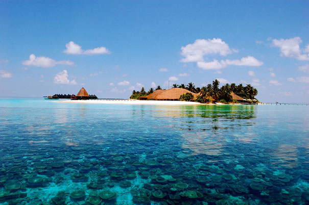
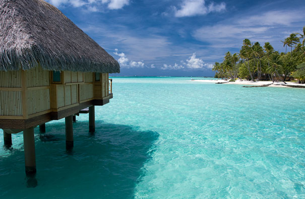 Bora Bora is a major international tourist destination, famous for its aqua-centric luxury resorts. The major settlement, Vaitape, is on the western side of the main island, opposite the main channel into the lagoon. Produce of the island is mostly limited to what can be obtained from the sea and the plentiful coconut trees, which were historically of economic importance for copra. According to a 2008census, Bora Bora has a permanent population of 8,880.
 The island was inhabited by Polynesian settlers around the 4th century AD. The first European sighting was made by Jakob Roggeveen in 1722. James Cook sighted the island in 1770 and landed that same year. The London Missionary Society arrived in 1820 and founded a Protestant church in 1890. Bora Bora was an independent kingdom until 1888 when its last queenTeriimaevarua III was forced to abdicate by the French who annexed the island as a colony.
 The commune of Bora-Bora is made up of the island of Bora Bora proper with its surroundingislets emerging from the coral reef, 29.3 km2 (11 sq mi) (11.3 sq mi) in total, and of the atoll ofTupai (11 km2 or 4.2 sq mi), located 20 kilometres (12 mi) north of Bora Bora.The atoll of Tupai has no permanent population apart from some workers in the coconut plantations.
 Most of the tourist destinations are aqua-centric; however it is possible to visit attractions on land such as WWII cannons. Air Tahiti has five or six flights daily to the Bora Bora Airport on Motu Mute from Tahiti (as well as from other islands). The island is served by Bora Bora Airport on Motu Mute in the north, with Air Tahiti providing daily flights to and from Papeete on Tahiti.
 Public transport on the island is nonexistent. Rental cars and bicycles are the recommended methods of transport. There are also small, two-seater buggies for hire in Vaitape. It is possible to rent a motorboat to explore the lagoon.
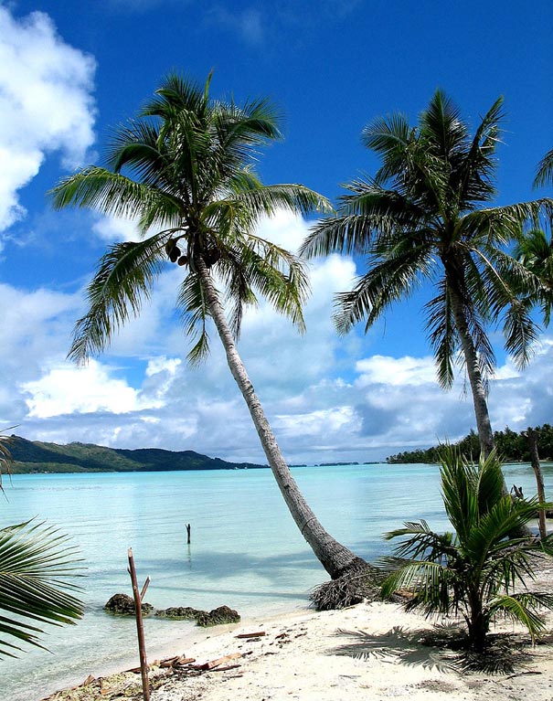


 The Inverted
Tower
The Inverted
Tower 
 The land that is now Quinta da Regaleira had many owners through time. But in 1892 it belonged to the Barons of Regaleira, a family of rich merchants from Porto, when it was purchased that year by Carvalho Monteiro for 25,000 réis. Monteiro wished to build a bewildering place where he could gather symbols that would reflect his interests and ideologies. With the assistance of the Italian architect Luigi Manini, he designed the 4-hectare estate with its enigmatic buildings, believed to hide symbols related to alchemy, Masonry, the Knights Templar, and the Rosicrucians. The architecture of the estate evokes Roman, Gothic, Renaissance and Manueline architectural styles. The construction of the current estate commenced in 1904 and most of it was concluded by 1910.
 The Taj Mahal from Persian and Arabic, "crown of palaces", pronounced is a white marble mausoleum located in Agra, Uttar Pradesh, India. It was built by Mughal emperor Shah Jahan in memory of his third wife, Mumtaz Mahal. The Taj Mahal is widely recognized as "the jewel of Muslim art in India and one of the universally admired masterpieces of the world's heritage".
 And the sun and the moon shed tears from their eyes.
 The Taj Mahal attracts a large number of tourists. UNESCO documented more than 2 million visitors in 2001, including more than 200,000 from overseas. A two tier pricing system is in place, with a significantly lower entrance fee for Indian citizens and a more expensive one for foreigners. Most tourists visit in the cooler months of October, November and February. Polluting traffic is not allowed near the complex and tourists must either walk from parking lots or catch an electric bus. The Khawasspuras (northern courtyards) are currently being restored for use as a new visitor center.
 The grounds are open from 06:00 to 19:00 weekdays, except for Friday when the complex is open for prayers at the mosque between 12:00 and 14:00. The complex is open for night viewing on the day of the full moon and two days before and after, excluding Fridays and the month of Ramadan. For security reasons only five items—water in transparent bottles, small video cameras, still cameras, mobile phones and small ladies' purses—are allowed inside the Taj Mahal.


.jpg)

.jpg)
.jpg) Although the Burmese temple designs evolved from Indic, Pyu (and possibly Mon) styles, the techniques of vaulting seem to have developed in Bagan itself. The earliest vaulted temples in Bagan date to the 11th century, while the vaulting did not become widespread in India until the late 12th century. The masonry of the buildings shows "an astonishing degree of perfection", where many of the immense structures survived the 1975 earthquake more or less intact. (Unfortunately, the vaulting techniques of the Bagan era were lost in the later periods. Only much smaller gu style temples were built after Bagan. In the 18th century, for example, King Bodawpaya attempted to build the Mingun Pagoda, in the form of spacious vaulted chambered temple but failed as craftsmen and masons of the later era had lost the knowledge of vaulting and keystone arching to reproduce the spacious interior space of the Bagan hollow temples.)
Although the Burmese temple designs evolved from Indic, Pyu (and possibly Mon) styles, the techniques of vaulting seem to have developed in Bagan itself. The earliest vaulted temples in Bagan date to the 11th century, while the vaulting did not become widespread in India until the late 12th century. The masonry of the buildings shows "an astonishing degree of perfection", where many of the immense structures survived the 1975 earthquake more or less intact. (Unfortunately, the vaulting techniques of the Bagan era were lost in the later periods. Only much smaller gu style temples were built after Bagan. In the 18th century, for example, King Bodawpaya attempted to build the Mingun Pagoda, in the form of spacious vaulted chambered temple but failed as craftsmen and masons of the later era had lost the knowledge of vaulting and keystone arching to reproduce the spacious interior space of the Bagan hollow temples.)